Release Note
Service outage announcement
GPXEV (GPX Editor and Viewer) will be out of service at the end of May 2022.
Please refer to the link below for details.
latest version
Version 0.14b (beta), Apr 25, 2022
- Bug Fixes
- [P0242] Even if you set your Google API Key in the Configuration dialog, you cannot use it during the usage limits period. This bug also occurs if you specify the api_key argument in the URL.
* This version will show "v0.14" instead of "v0.14b" on the screen.
Version 0.14a (beta), Feb 18, 2021
- Other
- [X0022] Changed the version of Google Maps API to quarterly channel. As a result, when Google upgrades the API, the version of the API used will also change. You can check the version of the API you are currently using in the Information dialog.
* This version will show "v0.14" instead of "v0.14a" on the screen.
Version 0.14 (beta), Sep 27, 2020
- What's new
- [N0028] You can change the size (radius) of the waypoint marker in the Configuration dialog.
- [N0029] The "time" tag can be automatically generated when saving a GPX file.
- What's changed
- [C0065] The minimum setting value of the route deviation parameter of the data volume reduction function was changed.
- [C0066] Changed the cursor shape of Current Waypoint from pointer to grab.
- [C0067] The cursor shape of the moving window was changed from pointer to grab.
- [C0068] If there are blank items in the Bounds dialog, an error will be displayed. Also, if the error is not resolved, the bounds tag will not be output to the GPX file.
- [C0069] If href is not entered in the Link dialog, an error will be displayed. Also, if the error is not resolved, the link tag will not be output to the GPX file.
- [C0070] If link href is not entered in the Author dialog, an error will be displayed. Also, if the error is not resolved, the link tag will not be output to the GPX file.
- [C0071] Increased the number of MIME types that can be automatically identified in the Link dialog.
- [C0072] If the size of the image is larger than the size of the Image View dialog, it will automatically shrink the image.
- [C0073] Adjusted the display position so that the route distance display does not overlap the color panel in the Route List dialog. If the route distance exceeds 10,000 km, the value after the decimal point will not be displayed.
- [C0074] Changed the behavior when the overwrite GPX metadata check box is turned off in the GPX tab of the Configuration dialog. The metadata values are updated only if you load the first GPX file without entering any values in the GPX Metadata dialog. If you manually delete all root data and then load the GPX file, the metadata values will also be updated.
- [C0075] The number of valid digits of the coordinates of the place search result in the Map Control dialog has been changed to 7 decimal places. This is a workaround for the problem that the 8th digit after the decimal point of the coordinates of the place search result of the Google Maps API contain an numerical error. However, the center coordinates of Google Maps in the search results may contain numerical errors due to the Javascript floating point specification.
- [C0076] Check the latitude, longitude, and zoom values of center and bounds specified in the URL argument. If the argument is incorrect, an error message will be displayed. The display coordinates of Google Maps are the initial values. This specification change applies only to GPXEV, not GPXVL.
- [C0077] Due to the specifications of Google Maps API, Name Marker cannot be displayed at a point with a longitude of 180 degrees. If you set the longitude of the additional name marker in the CGIParameter dialog to 180, it will be automatically corrected to -180.
- [C0078] Disable the spell checking feature of Firefox.
- [C0079] Changed the maximum distance of the elevation graph that can be drawn in the Elevation View dialog to 40,000km and the maximum elevation to 40,000m.
- [C0080] The unit of the vertical axis of the elevation graph drawn in the Elevation View dialog is automatically switched with "m" or "km".
- Bug Fixes
- [P0170] If you set the "additional name marker" latitude and longitude on the CGI Parameter dialog, error checking may not work.
- [P0171] If you click the bounds text box on the GPX Metadata dialog, you may get an error.
- [P0172] If you enter a comma separated coordinate string in the Waypoint dialog, an error occurs and the value is not split into latitude and longitude.
- [P0173] If you show hidden routes in the Route List dialog, locked waypoints may be displayed even if no waypoints are selected.
- [P0174] The cursor shape does not change to a pointer on some clickable controls.
- [P0175] If you click the Reset All button in the Custom Color Palette dialog, you may get an error.
- [P0176] If you click the Reset button when there is an input error in the GPX Metadata dialog, the error display will not be canceled.
- [P0177] If you load a GPX file that contains an incorrect time value, no error will be displayed in the GPX Metadata dialog.
- [P0178] If the current time is set automatically in the UTC+0 region, the time zone sign will be negative.
- [P0179] If you delete the email value in the Author dialog, only the domain attribute will be output to the email tag of the output GPX file. Therefore, the GPX file that does not conform to the XML schema will be output.
- [P0180] If there are blank items in the Bounds dialog, a GPX file that does not conform to the XML schema will be output.
- [P0181] If href is not entered in the Link dialog, a GPX file that does not conform to the XML schema will be output.
- [P0182] If link href is not entered in the Author dialog, a GPX file that does not conform to the XML schema will be output.
- [P0183] If you select a route that has no waypoint and click the Reset data button on the Services tab of the Tool dialog, an error will occur.
- [P0184] An empty name tag may be output to the GPX file even if you have not entered a name value in the Author dialog.
- [P0185] When you open the Link dialog, the correct link number may not be displayed.
- [P0186] If you enter "100" for the hue value in the Custom Color Palette dialog, the wrong color will be displayed.
- [P0187] The value of the synchronize stroke weight and map zoom level checkbox on the Path tab of the Configuration dialog always returns to its default value.
- [P0188] If you clear the in order to change the route check box on the Path tab of the Configuration dialog, the trkType route will work as configured, but the rteType and wptType routes will not work as configured.
- [P0189] If the Starting point marker is set to ON and the Destination point marker is set to OFF on the Waypoint tab of the Configuration dialog, it may not work as set.
- [P0190] If you close the browser with the marker display setting turned off on the Waypoint tab of the Configuration dialog, a marker with a shape different from the setting may be displayed when the display setting is changed to ON at the next startup. This bug also occurs when you change the display settings in the Marker Control dialog.
- [P0191] If you turn off the Dialog Control shortcut key setting on the Other tab of the Configuration dialog, the settings will not be saved and the values will be initialized each time.
- [P0192] If you click the Auto Fill from Google map button when there is an input error in the latitude, longitude, or zoom value of Google Maps in the CGI Parameter dialog, the error display will not be cleared.
- [P0193] If you manually enter the bounds value in the CGI Parameter dialog, the URL value is not updated.
- [P0194] If you manually enter an elevation value in the Waypoint dialog, the vertical scale of the Elevation View may not be updated and a graph may be drawn outside the dialog.
- [P0195] If the language setting is other than English or Japanese, the error dialog message may not be displayed correctly.
- [P0196] If the center and bounds latitude, longitude, and zoom values specified in the URL argument are incorrect, Google Maps may not be displayed.
- [P0197] If you hide the Starting point or Destination point markers on the Waypoint tab of the Configuration dialog, the radio buttons that select the marker shape will not be cascaded the next time you start gpxev.
- [P0198] If you use a specific dialog in succession with multiple dialogs open, the order in which the dialogs are displayed changes when the dialog is closed. This issue can cause dialogs that were hidden behind you to unintentionally bring to the foreground. Also, due to the side effect of this bug, two dialogs may be active at the same time.
- [P0199] The dialog display order changes before and after entering Route Edit mode.
- [P0200] If you click on a row that does not have a waypoint in the Route List dialog, the Current waypoint marker on Google Maps will not disappear. If you close the Waypoint dialog while this bug is occurring, the menu buttons will not be activated.
- [P0201] If you create a waypoint at a point where the longitude is -180 degrees, the longitude value may be set to 180.
- [P0202] If you manually edit the text displayed in the GPX Preview dialog, Cookie dialog or Exception dialog, the text will not be updated the next time you open the dialog.
- [P0203] If you manually edit the text displayed in the GPX Preview dialog, Cookie dialog, Exception dialog or CGI Parameter dialog, unintended shortcut keys may work.
- [P0204] There is an error in the plural notation of English words displayed in the Route List dialog and Temporary Storage dialog.
- [P0205] If there are routes that do not have any waypoints, the Temporary Storage dialog will display the wrong number of routes.
- [P0206] If you press the return key immediately after pressing any key while entering the time value in the GPX Metadata dialog, error checking may not work.
- [P0207] If you right-click an unselected route while the current route button is ON in route edit mode, the route will be deselected.
- [P0208] If you select a route while the Track Metadata dialog is open, the Metadata button in the Route List dialog will be activated.
- [P0209] If you close the Waypoint List dialog without selecting a route, the Waypoints button in the Route List dialog will be activated.
- [P0210] If you delete all routes while there is an input error on the GPX Metadata dialog, the error display will not be cleared.
- [P0211] When you click the Auto Fill button of bounds in the GPX Metadata dialog, the wptType waypoints are excluded from the aggregation.
- [P0212] If you click the Auto Fill button of bounds in the GPX Metadata dialog while the Bounds dialog is open, an error will occur.
- [P0213] If you select the check box on the Reducing tab of the Tool dialog while the root of wptType is selected, the Test button and Reduce button will be activated.
- [P0214] If you deselect a waypoint or route, the error display in the Waypoint dialog may not be cleared. This bug also occurs when deleting a route.
- [P0215] If you deselect a waypoint or route, the Color button in the Waypoint dialog may not be cascaded. If you click the Color button and select a color while this problem is occurring, an error will occur.
- [P0216] If the number of waypoints is less than the number of pixels in the width of the Elevation View dialog, the elevation graph will not draw correctly.
- [P0217] If you select a route that does not have any waypoints while the Elevation View dialog is open, an incorrect elevation graph will be drawn.
- [P0218] If there are waypoints over 7,000m elevation, a graph that extends outside the Elevation View dialog will be drawn.
- [P0219] If the total length of the route exceeds 8,000km, an error may occur in the Elevation View dialog.
- Other
- [X0020] The version of Google Maps Javascript API used by GPXEV has been changed to v3.41.
- [X0021] The text of the error message has been partially changed.
other version
Version 0.13.1 (beta), May 12, 2020
- What's new
- [N0027] Added the Batch tab to the Tool dialog. You can unlock all waypoints of the selected route at once.
- What's changed
- [C0064] Added the current route button to the Route Edit dialog. If this button is turned ON, even if you click another route while editing the route, the route will not be selected. This is a function to prevent accidental clicks.
- Bug Fixes
- [P0157] If you click the Starting point marker of another route while editing the route in Route Edit mode, the Current Waypoint Marker will move to the Destination point marker.
- [P0158] If you click the Reverse button on the Tool dialog without selecting a route, an error will occur.
- [P0159] When you open the Route Edit dialog, the initial state of the poi label button may not match the settings in the Map Control dialog.
- [P0160] You may not be able to enter the page number of the Waypoint List dialog.
- [P0161] Even if you have not set the initial coordinates of Google maps in the CGI argument at startup, the google maps check box in the CGI Parameter dialog will be ON.
- [P0162] If you turn off the "google maps" check box in the CGI Parameter dialog, the "center" and "bounds" radio buttons will not be grayed out.
- [P0163] Even if I change the value of bounds in the CGI Parameter dialog, error checking does not work.
- [P0164] If you press the ESC key after clicking the Append button in the Route List dialog, the window will not close. This bug only affects Firefox and Google Chrome.
- [P0165] If you press the ESC key to close the popup window, the window displayed at the top may also be closed.
- [P0166] The error check for the Brightness value in the Custom Color Palette dialog does not work properly.
- [P0167] Normally, you cannot select a wptType route in the route edit mode, but you can click the Name Marker to select a route.
- [P0168] You may be able to click the Commit button while an error is occurring in the Waypoint dialog.
- [P0169] It may be possible to click even if the Color button in the Waypoint dialog is grayed out.
- Other
- [X0018] The version of Google Maps Javascript API used by GPXEV has been changed to v3.40.
- [X0019] Added SameSite attribute to cookie.
Version 0.13 (beta), May 2, 2020
- What's new
- [N0019] Conversion tab has been added to the Tool dialog. You can reverse the start and end points of the route path.
- [N0020] Added Split button to Waypoint List dialog. You can split the route into two before and after the selected waypoint.
- [N0021] In the Route List dialog, you can select multiple routes by holding down the Shift key while clicking. If you click the Concatenate button with multiple routes selected, you can concatenate routes.
- [N0022] You can convert the latitude and longitude values from decimal to DMS (Degrees Minutes Seconds) format on the Tool dialog. You can also convert from DMS format to decimal.
- [N0023] If you right-click a route in the Route List dialog, you can change the order in which routes are displayed. With this function, you can change the order when concatenating routes.
- [N0024] If you right-click the route on the map, a shortcut menu will be displayed. If you click the Append button in the shortcut menu, you can add a waypoint.
- [N0025] You can change the color of the Name Marker. There are eight types of colors that can be selected from the GUI. The selected color can be saved in the GPX file's extensions tag. The color of Additional Name Marker can be specified by URL argument.
- [N0026] You can temporarily save the data you are editing in memory. This function can be executed with a simple operation of clicking a button on the menu. However, since the data is stored in the memory, the temporarily saved data will be lost when the browser is closed. This feature is enabled by the user changing settings in the Configuration dialog. In the future, we plan to implement a function to temporarily save data on the server side.
- What's changed
- [C0058] Changed the timing when the shortcut key of the right-click menu operates.
- [C0059] If you click on the currently selected route in the Route List dialog, you can deselect it.
- [C0060] When adding a route in the Route List dialog, the location to add a route changes depending on the position and type of the selected route. If you have not selected a route, add a new route at the end. If you have selected a route, add the new route on the line following the selected route. However, when saving a GPX file, route data is output in the order of wpt, rte, and trk in accordance with the GPX schema. Therefore, routes may not be output in the order displayed in the Route List dialog.
- [C0061] You can specify the boundary coordinates of the initial display position of the map in the argument of CGI. Either center coordinates or boundary coordinates can be specified as an argument.
- [C0062] Changed the style of grayed out text fields. The color is displayed slightly brighter than before.
- [C0063] wptType waypoints can also use Name Markers. If you use the wptType Name Marker, the Waypoint Information marker will not be displayed.
- Bug Fixes
- [P0141] When all windows are closed, if you right-click a waypoint and then enter a shortcut key, the shortcut keys in the menu will work. Also, if you press and release the key slowly, both shortcut keys will work.
- [P0142] If you add trkseg to a trk that is not the bottom line in the Route List dialog, trkseg may not be added at the correct position.
- [P0143] If you click another route while editing a route in Add mode, the guideline will be displayed in the wrong position.
- [P0145] If you click wptType waypoint in route edit mode, you may not be able to edit the route normally.
- [P0146] When exiting the route edit mode, the state of the menu buttons may be initialized.
- [P0147] If you click on the wptType marker, the route edit button in the menu will not be greyed out.
- [P0148] If you click the Append button in the Route List dialog, the shortcut keys will not work.
- [P0149] If you select the trkType route, you may not be able to open the Route View dialog.
- [P0150] If you select the trkType route, the button in the Route View dialog may not be clickable.
- [P0151] If the wptType route is selected, the Elevation View button in the menu display button may not be grayed out.
- [P0152] If you use Firefox or Google Chrome, the shortcut key of the dialog opened from the menu may not work properly.
- [P0153] If you click the Appned button in the Waypoint List dialog, the latitude or longitude of the waypoint may be set to a value out of the range defined in the GPX schema.
- [P0154] If you click the Auto Fill from Google map button in the CGI Parameter dialog, the latitude or longitude of the CGI argument may be set to a value out of the range defined in the GPX schema.
- [P0155] If you enter 90 for the latitude value in the Waypoint dialog, an error will be displayed.
- [P0156] The Waypoint Information marker may be displayed when you click the acitve button in the Route List dialog, even if you have not checked the "show information window" check box in the Configuration dialog. Similarly, even if routes are hidden in the Route List dialog, the Waypoint Information marker may be displayed when you check the "show information window" check box in the Configuration dialog.
- Other
- [X0016] ECMAScript2015 (ES6) Javascript syntax was used. It does not work on browsers that do not support ES6.
- [X0017] XML Schema for extension tag has been updated to v0.4.
Version 0.12.2 (beta), Feb 23, 2020
- What's changed
- [C0057] You can temporarily hide the guideline by pressing the Shift key in route editing mode.
- Bug Fixes
- [P0102] If you click Google Maps quickly and continuously in route edit mode, the guideline may not move along the cursor. If this problem occurs, scroll the Google map and the problem will be resolved. The details of this bug are currentlyIn the Lite version, the function to automatically adjust the display position of the map so that the route of the GPX file specified by the URL fits on the screen may not work properly.
We are currently investigating the details of this bug, but it may be a Google Maps API issue.This turned out to be a bug in the Google Maps API. Google Issue Tracker Number is 121006350. - [P0138] If you press the ESC key while moving the window, the window keeps moving.
- [P0139] If you drag and drop a route with only one waypoint in along the road mode, the destination point marker may be displayed at the wrong position.
- [P0140] The shortcut key of the menu displayed when right-clicking the waypoint may not work.
- [P0102] If you click Google Maps quickly and continuously in route edit mode, the guideline may not move along the cursor. If this problem occurs, scroll the Google map and the problem will be resolved. The details of this bug are currentlyIn the Lite version, the function to automatically adjust the display position of the map so that the route of the GPX file specified by the URL fits on the screen may not work properly.
- Other
- [X0014] Due to a bug in Google Maps, the callback may not return even if you move the mouse cursor on Google Maps while editing a route. At this time, the problem is forcibly resolved by redrawing the map. This is a provisional fix for the issue in [P0102]. This Google Maps bug does not occur if you move the mouse slowly. If Google fixes the bug in the future, I will remove this process.
- [X0015] Due to a bug in Google Maps, clicking on Google Maps while editing a route may not return a callback. At this time, the problem is solved by forcibly generating a click event. However, the waypoint created by this bug workaround may cause a slight difference between the coordinates on the map you click and the coordinates of the created waypoint. This Google Maps bug does not occur if you move the mouse slowly. If Google fixes the bug in the future, I will remove this process.
Version 0.12.1 (beta), Feb 18, 2020
- Bug Fixes
- [P0135] GPX files may not be saved.
- [P0136] If you right-click the button, the button will be displayed as if you left-clicked.
- [P0137] If you press the ESC key while clicking the window close button, the close button will not be displayed correctly the next time the window is displayed.
Version 0.12 (beta), Feb 16, 2020
- What's new
- [N0018] If you right-click the waypoint, a shortcut menu will appear. From this menu you can move, lock or delete waypoints. However, all menus can be used only when Current Waypoint Marker is clicked.
- What's changed
- [C0050] The timing to activate a window was changed from the moment the mouse button was released to the moment the mouse button was pressed. However, clicking some inactive controls does not activate the window. This limitation will be fixed in the future.
- [C0051] You can set the threshold value of the course change angle to judge that you are making a U-turn when reducing the data amount of Waypoint. This is the setting added to solve the problem of [P0117].
- [C0052] Some Notification dialogs can be hidden the next time. Hidden settings can be canceled in the Configuration dialog.
- [C0053] If the mouse cursor overlaps an existing route, marker, or guideline in Route edit mode, the drawing of the guideline does not stop.
- [C0054] You can create a new Waypoint on top of an existing route in Route Edit mode.
- [C0055] If you click the Copy button in the Search tab of the Map Control dialog, you can move the waypoint to the coordinates of the search result by right-clicking the waypoint and selecting "Move to saved lat-lng".
- [C0056] You can choose the mode of transportation when searching for routes along the road mode. If you choose "WALKING" as your means of transportation, you can also create a reverse route on a one-way street.
- Bug Fixes
- [P0108] If you click the "active" button in the Route List dialog, the Waypoint Information of "Clicked route" is not hidden, and the Waypoint Information of "Selected route" is hidden. Due to this bug, the display state of the unintended Waypoint Information changes. If you click the active button while trk is selected, the trkseg Waypoint Information contained in trk will not be hidden.
- [P0109] If you delete the URL in the Link dialog while displaying Waypoint Information, the Waypoint Information will not disappear from the map.
- [P0110] If you add a new waypoint at the end of the route in along the road mode, the lock button state in the Route Edit dialog will not change.
- [P0111] If you move the waypoint by drag and drop in along the road mode, the "avoid tolls" setting will not take effect.
- [P0112] If you are using Firefox or Google Chrome, you may not be able to copy text to the clipboard.
- [P0113] If you change the coordinates on the Waypoint dialog, the marker and Waypoint Information displayed on the map may not move to the new coordinates. In addition, if you create a new link with this problem occurring, Waypoint Information will be displayed at the coordinates before the change. This bug is a display problem and correct coordinates are output to the GPX file. If you move the waypoint by drag and drop while this bug is occurring, the marker and Waypoint Information will be displayed at the correct coordinates.
- [P0114] If you drag and drop the image displayed in Waypoint Information on the map, a problem will occur. If you are using Firefox or Google Chrome, you will not be able to continue editing the route. If you are using Internet Explorer, an error dialog will appear.
- [P0115] If you enter a value by paste from the clipboard in the Waypoint dialog, the focus may not move.
- [P0116] If you drag and drop a waypoint to a place where you cannot find a route in along the road mode, the guidelines will not disappear. For example, moving a waypoint to the sea may cause this issue. At this time, the number of waypoints displayed in the Route List dialog is not updated.
- [P0117]If you execute data reduction processing on a route that includes a U-turned waypoint (waypoint whose direction of movement changes by 180 degrees), unintended waypoints may be deleted.
- [P0118] In Route Edit mode, the button to open the Waypoint dialog on the menu may not be disabled.
- [P0119] If you load a GPX file that contains a trk tag that does not have a trkseg tag, or a GPX file that contains an rte tag that does not have an rtept tag, the route data will not be displayed in the Route List dialog. In addition, an error may occur if you click another route while this problem has occurred.
- [P0120] If you load a GPX file with trkseg tags that do not have trkpt tags, trkseg will not be displayed in the Route List dialog.
- [P0121] If you drag and drop the selected text string onto the map, you will not be able to continue editing the route. This bug is the same as [P0114].
- [P0122] Empty trk are not saved. This bug also occurs with rte tags.
- [P0123] You can click the lock button in the Waypoint dialog even when Waypoint is not selected. If you click the Commit button after clicking the lock button, an error will occur.
- [P0124] If you select a route in the Route List dialog, the button to open the Waypoint dialog on the menu may be activated.
- [P0125] If you click another route while editing a route in Route Edit mode, some menu icons become active.
- [P0126] If you add a waypoint in the middle of the route in Route Edit mode, the waypoint may be added at an unintended location. Specifically, apart from the waypoint on the straight line of the clicked route, if there is a waypoint closest to the clicked location, a new waypoint is added near the closest waypoint.
- [P0127] If the "show all items on the map" check box is checked in the Style tab of the Map Control dialog, the "poi label" button does not work properly in Route Edit mode.
- [P0128] If you click on a route, unintended Waypoints may be selected. This bug is the same as [P0126].
- [P0129] If you uncheck the "minimum distance" or "route deviation" check box on the Reducing tab of the Tool dialog, the text field will not be disabled at the next startup.
- [P0130] In the Lite version, markers are displayed at startup even if "off" is specified for "starting_point" and "destination_point "in the arguments. If you change the zoom level of the map, the markers will disappear. This bug occurs only in Lite version.
- [P0131] In the Lite version, the function to automatically adjust the display position of the map so that the route of the GPX file specified by the URL fits on the screen may not work properly. This bug occurs only in Lite version.
- [P0132] URL strings may not be updated in the CGI Parameter dialog.
- [P0133] If you press the shortcut key (space key, etc.) to change the selected waypoint while editing a route with no waypoint in Route Edit mode, an error will occur.
- [P0134] If you click the lock button while editing a route that does not have a waypoint in Route Edit mode, an error will occur.
- Other
- [X0013] The version of Google Maps Javascript API used by GPXEV has been changed to v3.39.
Version 0.11 (beta), Oct 29, 2019
- Bug Fixes
- [P0104] If the Waypoint dialog is closed when no route is selected on the Route List dialog, the Waypoint dialog cannot be opened from the menu even if waypoint is selected. If this problem occurs, you can open the Waypoint dialog by clicking the Edit button in the Waypoint List dialog.
- [P0107] If you use Firefox 70.0 (latest version), the cookie value will not be set correctly. This is because the specification of the default value of path related to Firefox cookies has been changed. Firefox 70.0 does not add a slash at the end of the path string generated by the browser if the cookie path value is omitted. The next released version will change the path value of all cookies.
- Other
- [X0012] Recreate the cookie created in the previous version when changing the settings. This fix changes the path value of cookies in Firefox version 70.0 or Google Chrome. This is a fix for the [P0107] issue.
Version 0.10 (beta), Oct 25, 2019
- What's new
- [N0017] Added the Google Maps Place Search function. You can also get the coordinates from the search results.
- What's changed
- [C0044] The algorithm for reducing the number of waypoints using "minimum distance" has been improved. If there are multiple waypoints within the specified distance, the waypoint that has less influence on the original route is deleted preferentially. Specifically, waypoints whose direction of travel changes significantly, such as turning right or left at an intersection, are not deleted.
- [C0045] The function to reduce the number of waypoints using "angle threshold" has been abolished. As an alternative, implement the functionality of [C0046].
- [C0046] Implemented the function to reduce the number of waypoints without changing the route shape as much as possible. You can reduce the number of waypoints by setting an acceptable route deviation before and after deleting the waypoints.
- [C0047] You can enter comma-separated coordinates in the latitude text field of the Waypoint dialog. If you enter a value that includes a comma, the value is automatically split into latitude and longitude.
- [C0048] If you add a waypoint at the end of a route in Route Edit mode, the Destination point marker is always redrawn.
- [C0049] If you drag a waypoint while pressing the Add button in Route Edit mode, the edit line is temporarily hidden. When the waypoint is moved, the edit line is redisplayed.
- Bug Fixes
- [P0093] If you remove the route of rteType or wptType and then open or close Waypoint Information, an error may occur.
- [P0094] If you reduce the number of waypoints using "angle threshold", the route may be incorrect because the waypoints are reduced unexpectedly.
- [P0095] If you reduce the number of waypoints using "minimum distance", some waypoints will not be deleted. Specifically, if there are 3 or more waypoints within the set distance range and the last waypoint is locked, the first waypoint is not deleted.
- [P0096] Buttons that are grayed out on the menu can be clicked. However, if you click, it will not work.
- [P0097] If you reduce the number of waypoints on the Tool dialog, Name Marker may not be deleted. This bug occurs when the Name Marker display is set to ON in the Marker Control dialog or CGI parameter. This bug occurs only when Name Marker display is not set for each Waypoint. In addition, an error will occur if you click the Name Marker left on the map due to this bug.
- [P0098] Even if the "waypoint lock status" checkbox is not checked in the Save Option dialog, the extensions tag may be output.
- [P0099] The Cancel button in the Save Option dialog may not work properly. If the "GPXEV's extentions tag" checkbox is checked when the dialog is opened, the lower checkbox will not return to the state before the dialog was opened even if the cancel button was clicked. This bug is a dialog display problem and does not affect the saved GPX file. As a result, there is a discrepancy between the settings on the Save Option dialog and the extensions tag of the output GPX file. Once the Save Option dialog and Save dialog are closed and the Save dialog is opened again, this discrepancy is resolved.
- [P0100] If you remove a route and then click the AutoFill button of bounds in the GPX Metadata dialog, an error may occur.
- [P0101] In route edit mode, if you drag and drop the Waypoint at the end of the route while pressing the add button, the guide line will not be redrawn. Therefore, a guide line is drawn with the waypoint before moving as the base point. This bug is only a display problem on the map and correct data is output.
- [P0103] If you scroll through the route list displayed in the Route List dialog and then delete all routes, the scroll position will not return to the initial position. If you create a new route from this state, the route you created will not appear on the dialog until you scroll.
- [P0105] If you select a waypoint, then hide the route and then redisplay the route, the waypoint will be deselected. At this time, Current Marker is hidden, but the Waypoint marker that was displayed before and after the selected Waypoint is redisplayed.
- [P0106] When obtaining elevation data from Google servers, the elevation data at the end of the route may not be set correctly.
Version 0.9 (beta), Aug 26, 2019
- What's new
- [N0010] You can create a route along the road. However, this feature frequently uses the Google Cloud Platform, which may limit the number of uses. If you are using your own API Key, GPXEV will not limit the number of uses.
- [N0011] You can set custom colors other than the default 64 colors for the route color. Custom colors can be created in the Configuration dialog.
- [N0012] You can use the keyboard for some dialogs. This has the same meaning as the Windows shortcut key, but does not use the CTRL key. When in route edit mode, you can switch commands with the keyboard.
- [N0013] You can delete all elevation data received from Google server. This function can also be used to delete all "ele" tags in the GPX file.
- [N0014] If you specify "mode = init" as a parameter of URL, the setting initialization screen will be displayed. If the GPXEV does not start properly, you can restore the default settings.
- [N0015] If the control does not have focus, you can use the keyboard to control map panning and zooming. This feature can be turned off in the Configuration dialog.
- [N0016] You can change the size of the Google Maps control icon.
- What's changed
- [C0016] You can open GPX file by drag & drop.
- [C0017] You can specify the number of significant digits of elevation data got from the Google Server. The default value is one decimal place.
- [C0018] You can specify the Google Maps API version and the API key of the CGI argument.
- [C0019] You can set API Key on the Configuration dialog. However, the API key of CGI argument has higher priority than it.
- [C0020] The color of the title bar of the currently selected dialog has been changed to blue.
- [C0021] If you move a dialog, it does not become translucent.
- [C0022] Customized buttons can also move the focus.
- [C0023] If you press the TAB key after displaying or selecting the dialog, the focus will move to the first control. However, some dialogs are excluded.
- [C0024] If you press the ESC key while the control has no focus, the dialog will close.
- [C0025] Dialogs located outside the screen will move into the screen the next time it is opened.
- [C0026] The Cookie View dialog will always refresh the display while open.
- [C0027] The order of items in the 4th and 5th tabs of the Configuration dialog has been changed.
- [C0028] When you hover the mouse over the Waypoint Marker, the cursor shape changes to pointer.
- [C0029] When the Waypoint List dialog is in Compact mode, the increase / decrease value at page movement has been changed from 10 (fixed) to 7 (number of lines).
- [C0030] The color has changed when the button of Route Edit dialog is clicked.
- [C0031] Not only the angle but also the distance can be specified as the condition for reducing waypoints in the Tool dialog.
- [C0032] You can specify Google maps style as a parameter of URL.
- [C0033] Added buttons to save, load, and reset Google map styles in the Map Control dialog.
- [C0034] Added a button to hide the Google maps poi (point of interest) in the Route Edit dialog.
- [C0035] You can set the default URL value in the Configuration dialog. This default value is used as the initial value for the CGI Parameter dialog and Load GPX dialog.
- [C0036] Changed so that Current Waypoint Marker is always displayed in front of Waypoint Marker.
- [C0037] Changed so that the same GPX file can be read continuously more than once.
- [C0038] Changed the specification of Waypoints selected after reducing the number of Waypoints in Tool Dialog. If you have selected a waypoint, the waypoint closest to the current waypoint is selected. If you have not selected a waypoint, no waypoint will be selected.
- [C0039] When you hover the mouse over the Name Marker, the cursor shape changes to pointer.
- [C0040] The Google Maps API version number is displayed in the Information dialog.
- [C0041] The minimum value that can be set for "align decimal point" on the Waypoint tab of the Configuration dialog has been changed from "1" to "4".
- [C0042] The Lite version does not change the cursor shape even when the mouse cursor is over the marker or route drawn on the Google map.
- [C0043] When the number of waypoints is reduced in the Tool dialog, the execution result is displayed in the Notification dialog.
- Bug Fixes
- [P0052] If you start GPXEV without specifying CGI parameters, Google Maps may not be displayed.
- [P0053] In route edit mode, if you remove the last waypoint from a route with only one waypoint, an error occurs.
- [P0054] In route edit mode, if you remove the waypoint at the end of the route, the Staring Point Marker does not move on the second waypoint.
- [P0055] After adding the Waypoint to the end of the route, if you click the Close button in the Route Edit dialog, the Destination Point Marker will not be displayed on the end of the route.
- [P0056] If you get elevation data from Google server while "Waypoint" dialog is open, the value of the acquired elevation data will not be displayed.
- [P0057] If you remove all data by clicking the trash box button on the toolbar, the window title is not initialized.
- [P0058] If you enter an incorrect value for "Window Opacity" in the "Configuration" dialog, an error occurs.
- [P0059] If you click the button that can not be pressed, the dialog you clicked may not be displayed in the foreground.
- [P0060] When the pop-up dialog is displayed by clicking the text field, the display order of the dialog may not change.
- [P0061] When the pop-up dialog is displayed by clicking the text field, the focus may not move.
- [P0062] If you keep changing the Z-order without closing the opened dialog, the Z-order of the dialog may be wrong.
- [P0063] If you select a route with no waypoint and get elevation data from Google Server, an error will occur.
- [P0064] If you select a route with no waypoint and reduce the number of waypoints on the Tool dialog, an error will occur.
- [P0065] If you close the "Configuration" dialog with the Color Palette dialog open, the Color Palette dialog remains on the screen.
- [P0066] The screen overlay may not be displayed properly when the color palette dialog is opened.
- [P0067] If you delete the year value in the Copyright dialog, error checking will not work properly.
- [P0068] The error check may not work properly when the Copyright dialog is displayed after the second time.
- [P0069] If you set the default value of author in the Configuration dialog, the Auto Fill button in the GPX Metadata dialog is not active until reloading.
- [P0070] The confirmation message when removing the route of "trkType" is displayed as "trkseg".
- [P0071] If you move the focus to a control that does not fit within the screen, the margins will be displayed.
- [P0072] The gridlines of the Elevation View dialog may be drawn outside the dialog.
- [P0073] You can click on a color palette that has been disabled in the Configuration dialog.
- [P0074] The same color code exists in the color palette. The color code of "cyan" is the same as "aqua", so it is changed to "lightblue".
- [P0075] If you perform another operation without entering a value while editing the name of the registered location in the Map Control dialog, the text field will remain without disappearing.
- [P0076] If you select a route with no waypoint and click on a button in the Route View dialog, an error will occur.
- [P0077] When the last page is displayed in the Waypoint List dialog, the selected list item will be deselected.
- [P0078] The coordinates displayed in the Waypoint dialog may not match the coordinates displayed in the Waypoint List dialog. Specifically, the coordinate values may differ by about 3 to 9 in the 14th decimal place.
- [P0079] If you register coordinate names including comma or semicolon in the Map Control dialog, the value will not be registered correctly.
- [P0080] If you set default metadata that contains comma or semicolon in the Configuration dialog, values will not be registered correctly.
- [P0081] When the "output extensions tag" checkbox in the Save Option dialog is unchecked, the "route color" checkbox and the "name marker visibility" checkbox are not disabled.
- [P0082] If you remove a waypoint displaying a Name Marker, the Name Marker may not disappear from the Google maps.
- [P0083] If there is no waypoint and you click the AutoFill button for bounds in the GPX Metadata dialog, an invalid value is output for the maxlon attribute of the bounds tag. The same problem occurs if you have checked the "auto calculate the bounds" checkbox in the Configuration dialog.
- [P0084] When clicking AutoFill button of bounds of GPX Metadata dialog, the value more than the number of significant digits may be set. The same problem occurs if you have checked the "auto calculate the bounds" checkbox in the Configuration dialog.
- [P0085] The thickness of the guide line displayed on Google Maps when editing a route is not linked to the zoom rate of the map.
- [P0086] If trkseg is added under the trk collapsed in the Route List dialog, trkseg is displayed on the screen, but trk does not change from the collapsed state.
- [P0087] If you load a GPX file with an error, you may not be able to continue.
- [P0088] An incorrect value may be entered for the initial value of "align decimal point" in the Waypoint tab of the Configuration dialog.
- [P0089] Even if a correct value is entered in "align decimal point" on the Waypoint tab of the Configuration dialog, it may be judged as an error.
- [P0090] If you select a trkType route and click the "Starting point" button in the Route View dialog, an error will occur.
- [P0091] If you remove the route with the Elevation View dialog open, the elevation graph will not be initialized.
- [P0092] If you use Firefox and open the Link dialog from the Track Metadata dialog, the Link dialog will be hidden behind the Track Metadata dialog. This bug does not occur in Google Chrome and Internet Explorer.
- Other
- [X0010] The version of Google Maps Javascript API used by GPXEV has been changed to v3.37.
- [X0011] XML Schema for extension tag has been updated to v0.3.
Version 0.8 (beta), June 13, 2019
- What's new
- [N0009] The Lite version that implements only the Viewer function has been released. Please see the Lite page for details.
- What's changed
- [C0015] Added radio button to specify application in CGI Parameter dialog.
- Bug Fixes
- [P0051] Even if the help message is hidden on the Configuration dialog, the help message may be displayed.
- Other
- [X0008] Added Malay and Arabic to the language of the help message.
- [X0009] Corrected an incorrect translation of an English help message.
Version 0.7 (beta), May 22, 2019
- What's new
- [N0008] Added CGI parameter to add Name Marker anywhere on the Google Map. With this argument, Name Marker can be displayed regardless of the GPX file.
- What's changed
- [C0010] If the name tag is described under the metadata tag when reading the GPX file, change the window title to the string of the name tag. The window title is also changed when the value of the name field is changed in the GPX Metadata dialog.
- [C0011] If a metadata tag is described in the GPX file read after the second time, only the child tag in which the value is described is used in the GPX Metadata dialog. If the child tag does not exist, the value of the text field of GPX Metadata dialog is not updated.
- [C0012] If you remove all the routes by clicking the toolbar button, the values in the GPX Metadata dialog will also be initialized. However, if you remove a route from the Route List dialog, it will not initialize the values in the GPX Metadata dialog.
- [C0013] Added Reset button to initialize all values in the GPX Metadata dialog.
- [C0014] Added Reset button to initialize all values in the Track Metadata dialog.
- Bug Fixes
- [P0041] You can click the Elevation View button on the toolbar even when trk(track) is selected. An error occurs when you click the button.
- [P0042] If you set "bounds" to GPX Metadata, incorrect attribute names will be output to GPX file. The "minlon" and "maxlon" attributes are misspelled.
- [P0043] While changing the color of the route on the Route List dialog, removing the route and then selecting the color causes an error.
- [P0044] If you load a GPX file with a metadata tag and then load a GPX file without a metadata tag, the text field in the GPX Metadata dialog displays the value, but the saved GPX files do not have metadata tags.
- [P0045] When changing the value of author in the GPX Metadata dialog, the default value set in the Configuration dialog may be displayed unintentionally.
- [P0046] If there are coordinates for which no value is set in the bounds tag, values for coordinates not set in the GPX Metadata dialog are also displayed. However, the correct bounds tag is output to the saved GPX file.
- [P0047] If Elevation View is displayed while selecting a route that does not have a waypoint, an error occurs.
- [P0048] If an entity is described in the GPX file and the character string that has been decoded contains an HTML tag, an invalid character string will be displayed on the dialog or Google maps. This bug may occur even if you enter a value in the text field of each dialog.
- [P0049] If you selected the language of help in the Configuration dialog, the settings may not be saved in the Cookie.
Version 0.6 (beta), May 10, 2019
- What's new
- [N0005] You can specify the Name Marker visibility setting for each waypoint. Added a check box for Name Marker visibility setting in the Waypoint dialog. This setting can be saved in the extensions tag.
- [N0006] You can specify whether to output for each type of extensions tag when saving GPX file. This setting can be specified on the Save Option dialog.
- [N0007] You can change the style of Google Maps. If you click the "Style" tab on the "Map Control" dialog, you can select the elements to be displayed on the map. If you reduce the elements displayed on the map, you will be able to create Waypoints anywhere with "Route Edit" mode.
- What's changed
- [C0006] Save Option dialog was changed to modal dialog.
- [C0007] If the extensions tag is described in the loaded GPX file, the Save Option dialog box is automatically checks the checkbox. GPXEV uses this value in preference to the value in the Configuration dialog. However, if you manually turn off the checkbox, the value of the check box will not turn on automatically until you reload the page.
- [C0008] If you click "Name Marker", you can select the waypoint.
- [C0009] If you specify "name_marker = ignore" as a CGI parameter, loading a GPX file with an extension tag will not display the Name Marker.
- Bug Fixes
- [P0028] If you remove the link of waypoint, the marker will reappear when show the route.
- [P0029] If you change the language setting of the help in the Configuration dialog after removing the route data in the Route List dialog, an error will occur.
- [P0030] If you move the cursor over the Active button in the Route List dialog, the shape of the cursor does not change.
- [P0031] If you enter an incorrect value for geoidheight, magvar or dgpsid in the Waypoint dialog will not cause an error.
- [P0032] The integer value check may not work correctly for valuesthat include a decimal point.
- [P0033] Entering a datetime value containing milliseconds will cause an error.
- [P0034] If you remove all route data, you can not click the GPX metadata button on the toolbar.
- [P0035] If you load a GPX file that contains the "extensions" tag, the color of the route may not change.
- [P0036] When the Waypoint dialog is open, you can not create the second or subsequent waypoints from the Waypoint List dialog.
- [P0037] If you select a waypoint that is not displayed on the map in the "Waypoint List" dialog, only markers will be displayed on the map.
- [P0038] Even if you enter a date and time value that contains invalid characters, an error may not occur.
- [P0039] If you load a GPX file that does not describe a copyright tag, "0" is displayed in the copyright field of the GPX Metadata dialog.
- [P0039] If you load a GPX file that has "metadata" tag but not "copyright" tag, "0" is displayed in the copyright field of the GPX Metadata dialog.
- [P0040] If you enter a value in the "number" field of the Track Metadata dialog, an error may occur.
- Other
- [X0004] The script size has been reduced by using external help message files.
- [X0005] Output setting of extension tag was added to the Configuration dialog.
- [X0006] XML Schema for extension tag has been updated to v0.2.
- [X0007] The version of Google Maps Javascript API used by GPXEV has been changed to v3.35. The problem of P0024 is solved by the API correction of Google side.
Version 0.5 (beta), Jan 25, 2019
- What's changed
- [C0004] If you click the waypoint information marker, you can select a waypoint.
- [C0005] If you hide the currently selected route, the contents of the waypoint dialog will be initialized.
- Bug Fixes
- [P0007] If you remove a link from the waypoint of wptType, the marker on the map also disappears.
- [P0008] If the route is wptType, the "Waypoint Information" may be redisplayed even if you remove the waypoint link.
- [P0021] Even if you click the "active" button in the "Route List" dialog, "Name Marker" will not be hidden.
- [P0022] If the route is wptType, the color of the marker may not be set automatically.
- [P0023] If you load a GPX file used a custom namespace, an incorrect namespace may be output when saving the GPX file.
- [P0024] If you use Internet Explorer 11, Google Maps drawing speed may be extremely slow. This bug is caused by Google Maps Javascript API v3.35.
- [P0025] If you change the zoom ratio of Google Maps, the markers of the routes that are not displayed may be displayed.
- [P0026] If you load a GPX file that describes latitude or longitude of 14 digits or more after the decimal point, latitude or longitude of 13 digits after the decimal point may be output.
- Other
- [X0002] Error handling when loading GPX file has been improved.
- [X0003] Changed version of Google Maps Javascript API to v3.34. This is an provisional solution to P0025.
Version 0.4 (beta), Dec 6, 2018
- What's new
- [N0001] GPXEV supports extensions tag of GPX. GPXEV can load the GPX file in which the extensions tag is described. However, the user can not edit the contents of the extensions tag.
- [N0002] The Save Option dialog was added. GPXEV can output the color of the route to the extensions tag of the GPX file.
- [N0003] Added the new function to display Name Marker. The specification of Name Marker may change in the future.
- [N0004] Added CGI parameter to set marker display status.
- What's changed
- [C0003] If you click on the marker after closing Waypoint Information, Waypoint Information will be displayed again.
- Bug Fixes
- [P0010] Even if you turn off the display of Route Marker on the Marker Control dialog, the Route Marker may be displayed. The first case is when you load a GPX file. The second case is when you click the active button on the Route List dialog.
- [P0011] If you close the Route List dialog, the color palette may not be displayed the next time you open the Route List dialog.
- [P0012] rteType metadata may not be write when GPX file is saved.
- [P0013] If you change the coordinates of the starting point or the ending point of the route on the Waypoint dialog, the markers on the map will not move.
- [P0014] If you create a new route on the Route List dialog, you can not open the Waypoint Dialog from the toolbar.
- [P0015] Even if you edit "name" of rteType in the "Track Metadata" dialog, the route name will not be changed in the "Route List" dialog.
- [P0016] Items of rteType and wptType are displayed shifted to the left of trkType on Route List dialog.
- [P0017] Even if there is route data, the remove all route button on the tool bar may not become active.
- [P0018] If you specify a gpx file containing link information in the URL, the center coordinates of the map may not move to the specified position.
- [P0019] When clicking the "active" button of wptType on the "Route List" dialog, the center coordinates of the map may move automatically.
- [P0020] If loading a gpx file that does not exist the "name" tag, the "name tag" written as "no name" is output. This bug occurs with the child tag of the trk and rte tags.
- Other
- [X0001] GPXEV records the last used version number in cookie.
Version 0.3 (beta), Nov 12, 2018
- Bug Fixes
- [P0009] Due to specification change of Google Maps, GPXEV may not start on Internet Explorer and Firefox.
Version 0.2 (beta), Oct 13, 2018
- What's changed
- [C0001] If GPXEV is executed with only GPX file name specified in the URL, the coordinates and zoom factor of Google Maps are automatically adjusted so that the entire route can fit within the screen.
- [C0002] If you are using an older version, GPXEV will tell you that a new version was released at startup.
- Bug Fixes
- [P0001] The button to increase / decrease the value of "Stroke opacity" on the Path tab of the Configuration dialog does not work properly.
- [P0002] When route is newly created, the size of the Current Marker does not correspond to the zoom ratio of Google Maps.
- [P0003] If you start GPXEV with GPX file(URL), latitude(lat), longitude(lng) specified, the initial display position of Google Map may be out of the specified coordinates.
- [P0004] If you load a new gpx file while a waypoint is selected, the current marker will not be displayed correctly.
- [P0005] If you select trk in the Route List dialog and click the Full view button on the Route View dialog, an error will occur.
- [P0006] If you remove a waypoint on the Waypoint List dialog, the waypoint you clicked next may be unintentionally removed.
Version 0.1 (beta), May 8, 2018
It's first released version.
Known Issues
Bug
- [P0144] If the position you clicked in the along the road mode is far from the end point of the searched route, the guideline may not be displayed in the correct position. (* This bug occurs infrequently, and the conditions under which it occurs are unknown at this time. The priority of this bug fix has been lowered.)
- [P0220] If you click the Concatenate button in the Route List dialog, some buttons on the menu will not be activated.
- [P0221] If you deselect the route while holding down the Shift key when two routes are selected in the Route List dialog, some buttons on the menu will not be activated.
- [P0222] If you change the value of the name tag for the waypoint of wptType that is displayed the Name Marker, Google's default marker will be displayed.
- [P0223] If you set the date and time to a time zone other than 00 minutes in the Waypoint dialog, an error will occur.
- [P0224] If you open the Link dialog with the Waypoint dialog displayed at the edge of the screen, part of the dialog will be displayed off-screen.
- [P0225] If you click the × button in the upper right to close the Save Option dialog, the value of the checkbox will not return to its original state.
- [P0226] If you specify an image format other than Jpeg for MimeType on the Link dialog, the Waypoint Information dialog may not be displayed.
- [P0227] If you change the coordinate value on the Waypoint dialog, the value of route distance displayed on the Route List dialog may not be updated.
- [P0228] If you deselect one of the two routes selected in the RouteList dialog, some functions will not be available. Specifically, some icons on the menu and the Metadata button in the Route List dialog will not be activated. Also, if those dialogs are already open, the buttons, texts, graphs, etc. displayed on the dialogs will not be updated.
- [P0229] If you change the checkbox or radio button on the dialog by operating the keyboard, it may not work properly.
- [P0230] Even if you change the scale of the dialog, the dialog with the scale changes may not be displayed at the next startup. This bug can only occur in dialogs that are used for the first time.
- [P0231] In the Map Control dialog, if you turn on the top check box when the edit radio button is selected on the Style tab, the bottom check box will not be cascaded.
- [P0232] If you click the Custom Color Palette button in the Configuration dialog, the button is not grayed out. If you click the Custom Color Palette button again while the Custom Color Palette dialog is open, the custom color you are editing will be initialized.
- [P0233] If you click the Reset All button in the Custom Color Palette dialog and then exit without changing the color palette, the color palette will not return to the default values the next time you launch it.
- [P0234] When you click a waypoint (row) displayed in the Waypoint List dialog, the text may shake up and down. This bug occurs depending on your environment.
- [P0235] If you press the ESC key immediately after loading a route containing a waypoint with an external link image from Temporary Storage, the Waypoint Information window will close instead of the Temporary Storage dialog.
- [P0236] If you click the "Now Date" button in the GPX Metadata dialog in a region where the time zone minute is not "00", the wrong time zone value will be set.
- [P0237] If the date and time character string contains a space or a period, the error may not be detected.
- [P0238] If the numeric data (latitude, longitude, altitude, GPS track number, etc) contains a space, the error may not be detected.
- [P0239] If you press the shortcut key "C" in the CGI Parameter dialog to copy the URL string to the clipboard, the URL string displayed on the screen disappears.
- [P0240] Shortcut keys in the Waypoint List dialog may not work properly.
- [P0241] If the latitude or longitude value in the Waypoint dialog is incorrect and you select "Move to saved lat-lng" from the waypoint pop-up menu, the error display will not be cleared.
- [P0243] If you delete the Google API Key that has already been set in the Configuration dialog, the settings will not be initialized.
There is no problem confirmed at the moment.
Last Updated: Apr 25, 2022
Limitations
1. Create Waypoint
There are places where new markers can not be placed when editing the route. There are two ways to solve this problem.
The first solution is to move the marker after placing the marker once.

You can not add a waypoint on the label.

Click once outside the label.

Drag and drop the marker to the target point.
The second solution is to hide the item displayed on Google map. You can use the Style tab of the Map Control dialog to hide items such as store names and station names that get in the way when editing a route.

2. Significant figures
Due to limitations of Javascript, the number of significant digits of latitude or longitude is 13 to 16 digits after the decimal point. If you move the Waypoint marker on Google Maps, the number of significant digits may be reduced from the value originally described in the GPX file. However, if you do not move the Waypoint marker, the value written in the loaded GPX file will be output as is. In addition, the Javascript constraint takes precedence over the value set in "align decimal point" of "Latitude / Longitude" in the Configuration dialog.

Here is a simple example. The decimal longitude "179.99999999999994" is the binary number "0110-0111-1111-1111-1111-1111-1111-1111-1111-1111-1111-1111-1110". However, "0110-0111-1111-1111-1111-1111-1111-1111-1111-1111-1111-1111-1111" binary number is "179.99999999999997" in decimal number. Therefore, longitudes "179.99999999999995" and "179.99999999999996" cannot be expressed in double precision floating point. This is why the latitude and longitude are inaccurate. However, not all latitudes and longitudes cause an error at the 14th decimal place. The number of significant digits after the decimal point varies depending on the value of the integer part.
3. Loading GPX file by HTTPS or HTTP

When reading GPX files on the Internet using HTTP, the server must allow CORS(Cross-Origin Resource Sharing). Specifically, "Access-Control-Allow-Origin" must be specified in the HTTP reply header returned by the server to the client.
The way to set up .htaccess using the apache is as follows.
- Create .htaccess file in the directory containing the GPX file of the server.
- Write the following line in the .htaccess file.
Header append Access-Control-Allow-Origin: "https://askz.sakura.ne.jp"
( or "http://askz.sakura.ne.jp" )
[NOTE]
- If the headers_module in httpd.conf is commented out, you need to delete the "#" at the beginning of the line. You need to set "AllowOverride FileInfo" in the "Directory" section of httpd.conf.
- Error code 8201 is occurred when GPX file is read from server which CORS is not permitted.
- If your server does not support SSL (https), please use GPXEV by http(http://askz.sakura.ne.jp/gpxev/gpx_editor_and_viewer.cgi).
| GPXEV URL | |||
|---|---|---|---|
| HTTPS | HTTP | ||
| GPX file URL | HTTPS | ◯ | ◯ |
| HTTP | ⨯ | ◯ | |
Bibliography:
- Access-Control-Allow-Origin
https://developer.mozilla.org/en-US/docs/Web/HTTP/Headers/Access-Control-Allow-Origin/ - CORS(Cross-Origin Resource Sharing)
https://developer.mozilla.org/en-US/docs/Web/HTTP/CORS/
4. XML Entity
If the loaded GPX file contains entities other than amp, lt, and gt, decoded characters are output to the saved GPX file.
5. Internet Explorer 11 performance issues
Internet Explorer 11 has performance issues.
- IE11 processing time may take approximately 3 times longer than Google Chrome and Firefox.
- If many Name Markers are displayed on Google Maps, the processing speed will be significantly reduced. The processing speed of IE11 depends on the performance of the personal computer, but it will deteriorate visibly when the number of Name Markers displayed exceeds 50. This issue does not occur with Google Chrome or Firefox.
Implementation Schedule
Next Release
There are no implementation plans at this time.
The specifications planned for the next release version are as follows.
- What's new
- [N0028] You can change the color of items such as roads and labels displayed on Google Maps.
- [N0029] Added Date and Time dialog. In this dialog, you can edit the date and time, calculate the estimated transit time, and set the time zone all at once.
- [N0030] To prevent erroneous operation, a confirmation dialog is displayed when the page of browser is moved while editing the route. This function is initially turned off and can be used by changing the settings in the Configuration dialog.
- [N0031] Only the specified items can be deleted for all waypoints of the selected route.
- [N0032] You can specify the MapID created by Google Maps Platform. However, if you specify MapID, you cannot change the settings of the objects displayed in Google Maps on the Map Control dialog.
- [N0033] If you hold down the increase / decrease button, the value will increase or decrease continuously.
- [N0034] If you press a button using a shortcut key, the style of the button will change as if you clicked the button with the mouse. However, if the dialog is closed by pressing a shortcut key, the button style does not change.
- What's changed
- [C0081] The format of the string described in the time tag is now strictly checked. If a character string that violates the GPX specifications is described in the loaded GPX file, the time tag will not be output when the GPX file is saved.
- [C0082] If there is no response from the Google Maps server after startup, an error screen will be displayed. The error code is 8371.
- [C0083] Renamed the Services tab of the Tool dialog to "Elevation". Along with this specification change, the shortcut key of the Tool dialog has also been changed.
- [C0084] When you get the elevation data from Google server, you can choose whether to overwrite the elevation that has already been set.
- [C0085] When deleting elevation data in bulk on the Elevation tab of the Tool dialog, only the values obtained from the Google server will be deleted. If you want to delete all elevation data, use the Batch tab of the Tool dialog.
- [C0086] You can change the location where Temporary Storage stores data from memory to local storage.
- [C0087] The number of colors that can be set for Name Marker has been increased to 16.
- [C0088] The background color of the Additional Name Marker drop-down list in the CGI Parameter dialog has been changed to the selected color.
- [C0089] The Style tab in the Map Control dialog has been renamed to the Object tab. Due to this change, the shortcut keys on the Map Control dialog have been changed.
- [C0090] The format of the setting to save in cookies has been changed. Due to this specification change, the settings used by GPXEV are only upward compatible, not backward compatible. Specifically, the settings changed in v0.14 can be used in v0.15, but the settings changed in v0.15 cannot be used in v0.14. For the time being, both new (v0.15 and later) and old (v0.14 and earlier) settings will be saved in cookies.
- [C0091] If the settings at the time of the previous execution could not be obtained due to a browser malfunction or the user intentionally changing the contents of the cookie, the settings are initialized.
- [C0092] The notification message when a new version is released is displayed only once per version. For example, if you execute v0.15, v1.00, v0.15 in that order, the message will not be displayed when you execute it for the third time.
- [C0093] You can now save up to 5 sets of color palettes (64 x 5 = 320 colors). Due to this specification change, when you click the Reset All button in the Custom Color Palette dialog, only one set of color settings will be reset. In addition, a button to change the set number has been added to the Color Palette dialog.
[C0094] You can now save up to 5 sets of Google Maps object settings. Due to this specification change, the Save and Load buttons in the Map Control dialog have been deleted and a Copy button has been added.- [C0095] A confirmation screen is displayed when you reset the settings of the route color in the Configuration dialog.
- [C0096] A confirmation screen is displayed when you reset the settings of the objects of Google Maps in the Map Control dialog.
- [C0097] You can specify the color setting or MapID of the object to be displayed on Google Maps in the startup argument. Due to this specification change, the screen configuration of the CGI Parameter dialog has been changed.
- [C0098] When you click on a color box in the Custom Color Palette dialog, the color picker dialog opens. The specifications of the color picker dialog depend on the OS and browser you are using.
- [C0099] When the value increase / decrease button is clicked, it is displayed in fixed-point notation. For example, the "ratio" in the Configuration dialog displays "1" as "1.0".
- Other
- [X0022] Internet Explorer 11 will no longer be supported. The warning message about Internet Explorer 11 that was displayed on the screen will no longer be displayed.
- [X0023] XML Schema for extension tag has been updated to v0.5.
The next release, v0.15, will be the final beta (Release Candidate).
Example
1. Touring map around Mount Fuji (rteType)
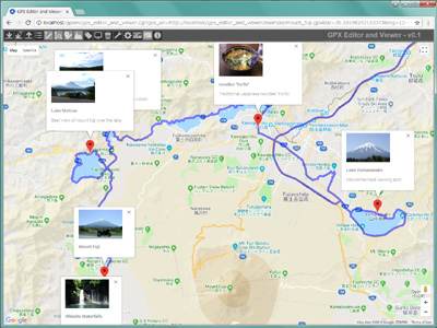
It's recommended route around Mount Fuji for riding a motorcycle in Japan.
This is example GPX file of "rteType", contains 2,691 waypoints and 6 external links(199kbyte).
2. Map of shrines and temples in Japan (wptType)
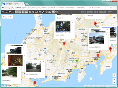
It's a map of famous shrines and temples in Japan.
This is small example GPX file of "wptType", contains 17 points(4.6kbyte).
3. Cross the Japanese archipelago (trkType)
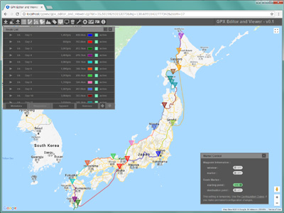
It's a route to cross the Japanese archipelago by motorcycle. It took 15 days.
This is large example GPX file of "trkType", contains 15 tracks and 29,087 waypoints(2,275kbyte). Click button, if you would like to hide the information window on Google Maps.
[NOTE]
This is an example of a huge GPX file. It takes about 1 minute to display the route on Google Maps.